Unmanned Traffic Management (UTM) is a critical step in full integration of drones into the airspace. Until a robust framework that allows manned aircraft pilots and airports to feel confident that they know exactly what’s in the airspace, commercial drone applications will be limited – and safety will continue to be a concern.
UTM isn’t one thing – it’s a complex structure of regulations, technologies, and software. Partnerships and collaborations are forming rapidly as the leading players work to provide a flexible framework that includes all of the necessary components. While UTM includes drone tracking and ID, airspace intelligence, and communications systems so that drones and air traffic control can stay connected, another important feature of UTM is counter drone technology.
This week is AUVSI’s Xponential show – and safety and security experts Fortem Technologies announced today a partnership with Unifly, a leading UTM provider. The two “will collaborate to develop a joint airspace safety and security solution for a drone-enabled society,” says a Fortem press release. “This new end-to-end solution will allow UTM and U-space architectures to be used by public safety officers, military groups and other government agencies to secure airspace around critical infrastructure, airports, stadiums, public venues and more.”
This announcement follows on the heels of last month’s announcement that Fortem had partnered with AirMap, another leading airspace intelligence and UTM platform. DRONELIFE had the opportunity to speak with Timothy Bean, Fortem Technologies’ CEO, to find out why counter drone technology – or rather, airspace security – solutions are so important to UTM.
Bean begins by giving me a crash course in Fortem’s drone security system. “Two or three years ago if you wanted to stop a drone, you’d buy an antenna,” says Bean. “The antenna could hear the drone signal, and if you didn’t want it there, you could just jam the signal… and then you’d go look for the guy with the joystick,” he laughs.
As drone technology has advanced, however, the threats have gotten more sophisticated. “Drones are flying on iPads, not joysticks, now. That antenna has nothing to listen to – the drones are flying around listening to GPS,” explains Bean. “And the bigger threat is that drones are now flying on terrain maps – they aren’t even listening to GPS, they are designed for a GPS deprived envioronment.”
“That’s scary,” says Bean. “The operator can be hundreds of miles away – there is no operator.”
That’s why radar has become important in drone detection – but not the traditional large equipment. “Radar is usually big,” explains Bean. “It weighs about 50 pounds, sometimes you need your own power station, and traditional radar has a narrow point of view.”
“The other problem is that radar can’t see through buildings,” he continues. “Radar sees day and night, and through clouds: but it’s topology challenged, it can’t see through buildings and through hills.”
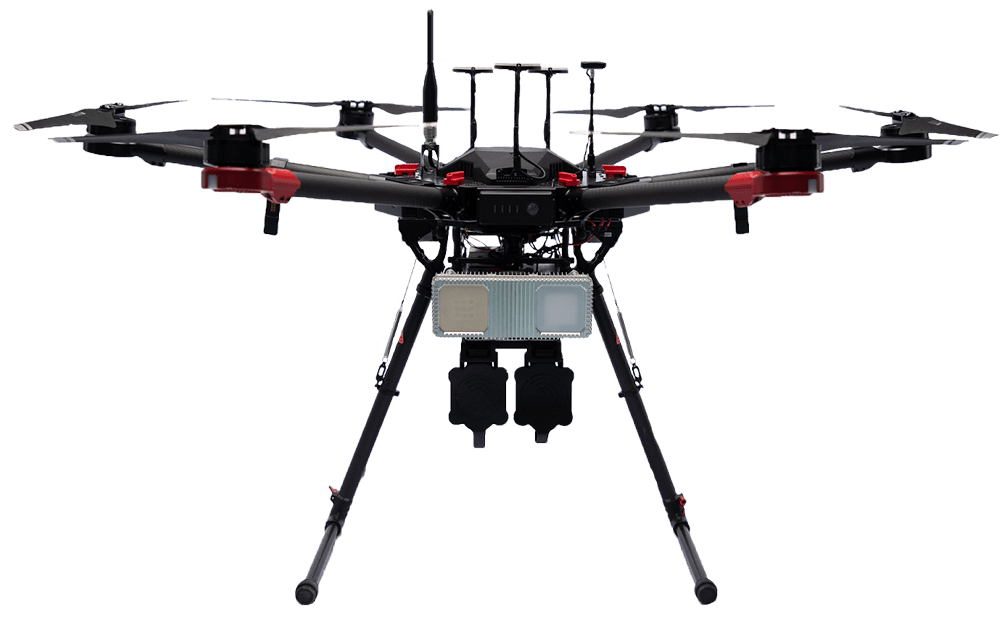
Fortem’s radar is a different thing. “Our disruption is that we’ve built a small radar – one is the size of a pencil case, and one is the size of a laptop. They see 120×120 – so we can put them on all sides of a building, or all over a city – and then we aggregate the data with our software to give you complete visibility, about a mile in the sky,” Bean says.
The Fortem platform offers other advantages. “People don’t like radar because it is stochastic, and you get a lot of false positives. That’s why traditional long range radar takes time to focus in on something.”
“Another big disruption that our technology offers is the NVIDIA chip that goes in the radar to get rid of all of the noise.” NVIDIA is the leading maker of edge AI technology – they’ve miniaturized their computer to allow powerful processing on small devices, which is known as “edge” computing. With edge computing on Fortem’s radars, they’re able to achieve more accurate results: 1 meter as opposed to 50 – 100 meters. Software associates the tracks from all of the radars positioned around a protected area to get one single picture of everything in the airspace.

image courtesy Fortem Technologies
“With that 3D view, we can create these geofences,” says Bean. “Customers can create rules about what they want to happen when a drone enters that area – to communicate with the operator, or with authorities, or to use the DroneHunter to take it down.”
By collaborating with UTM providers like Unifly, Fortem can differentiate between drones with a legitimate purpose in the airspace and those that don’t belong. Bean gives an example: a customer protecting some piece of critical infrastructure might have 5 drones flying for inspection purposes, and using Unifly for airspace intelligence. Identifying every drone in the airspace using radar, Fortem’s software can then eliminate those in the Unifly system from the list of potential threats. They may choose to communicate with the provider rather than take measures towards mitigation.
The total solution is an elegant one – and one that takes into consideration the needs of organizations who want to protect their airspace, while also taking advantage of the benefits of commercial drones.
The following is taken from a Fortem press release.
“Recent security breaches have caused the demand for digitized airspace above a venue or across a city to skyrocket, particularly for solutions that can detect drones with no RF emissions,” said Fortem Technologies CEO Timothy Bean, “Fortem SkyDome supports drone service providers like Unifly to pave the way for safe and secure drone operations in an urban environment.”
Unifly recently announced Unifly BLIP (Broadcast Location and Identity Platform), an e-Identification sensor that detects position, altitude, temperature, pressure, speed and direction, when placed directly on a drone. This information can be accessed in real-time by relevant authorities, such as police officers or government organizations, through secured applications. Fortem SkyDome is an AI data platform that uses distributed Fortem TrueView radar to digitize the airspace above and around infrastructure, venues, events and cities, for approved drones to fly safely and unapproved drones to be identified quickly. The new joint solution will combine and leverage the capabilities offered by these solutions.
“Safety and situational awareness are the two key elements that come into play for organizations working to develop and deploy new drone technology,” said Laurent Huenaerts, General Manager of Unifly. “Combining Unifly’s solutions with Fortem’s is a milestone that will allow us to serve the needs of more stakeholders and accelerate towards the safe drone-enabled airspace we envision.”
Fortem Technologies and Unifly were both chosen to participate in the UAS Integration Pilot Program, which sets out to accelerate the safe integration of UAS into the airspace. Fortem is also running tests with various Departments of Transportation (DOT) at the state level, and Fortem SkyDome is being tested by the Utah Department of Transportation at Salt Lake City Airport, as well as with additional domestic and international airports. Unifly and Fortem have also both partnered with the State of Nevada UAS Test Site for the FAA UTM Pilot Program, a joint initiative from the FAA and NASA that seeks to manage the airspace for the safe deployment of drones in the US National Airspace System (NAS).